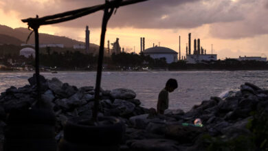
You're looking at the refugees of tomorrow. Presumed sea-level rise due to global climate change over the next nine decades, coupled with the accelerated erosion of the Nile Delta's coast as a result of 150 years of damming the Nile's flow, threaten villages, towns and cities of up to six million people. Roughly 7.5 percent of Egypt's population is in danger, as well as possibly one million feddans – 4500km2 of crop land, a fifth of the delta's area and, more importantly, almost 12 percent of the nation's arable land.
These are figures the United Nations Environment Panel (UNEP) released as part of its report to identify the top areas that are vulnerable to global climate change, just another disaster in addition to existing excessive taxation on the country's agricultural land. These figures and trends indicate Egypt will struggle to meet both the nutrition and housing needs of its growing population.
But before we scramble for cover and call on the ministers, scientists and businessmen for action, a little dose of history is required. Like many river delta regions around the world, the Nile's delta has proved an unruly place to live, where settlements have been through various cycles of calm and chaos over the last 3000 years.
The people of the delta have had to flee or adapt to migrating and decaying branches, tsunamis, earthquakes, inundation, sinking land, dune migration and severe coastal erosion. Not exactly a bastion of calm.
Ancient Egyptian Dynasties
The Nile delta is one of Egypt's younger land formations, reaching a complete state around 7000 years ago after taking nearly a thousand years to form, pushing the front line of the Nile and Mediterranean out over 100km.
A relative adolescent compared to the rest of the valley and to the many million year-old deserts, and thus, is still in a dynamic state of flux and much more sensitive to natural or man made changes.
Early Egyptians populated the delta and settled along the banks of its seven or so original branches almost immediately after it formed. Pe, known in Greek times as Buto, was the capital of the Te-Mehu, land of the papyrus plant. The oldest intact settlement found to date is present-day Merimde Beni Salama, about 50km north west of Cairo, which dates to 3800 BCE, almost six centuries before the legendary Menes unified Upper and Lower Egypt.
The ancient Egyptian empire that followed found great wealth in the delta's fertile soil, its produce far exceeding the country's needs. Surplus crops were shipped down the meandering waterways and over the Mediterranean to be traded with nearby states for the gold that would fuel the empire's massive construction campaigns and the growth of its imperial armies.
Cities sprang up almost everywhere in the delta to meet this agricultural and transportation boom. Important cities like Pelusium in the northeast, Sebbynitos in the north, and Canopis, Heraklion and the pre-Alexandrian Rhakotis to the northwest dotted the delta's Mediterranean coastline where the river branches met the sea and thrived as crucial sea ports.
From the coast to the delta's heart, no less than four ancient Egyptian capitals–Per Rames, Tanis, Mendes and Alexandria–were established across its history. At times some were founded to administer the empire's expansion into Asia, most notably after the Hyksos’ capital of Avaris fell under Ahmose, signaling the dawn of the New Kingdom.
The cities of the delta witnessed the exodus of Moses and produced the kings of the later Egyptian dynasties as well as one of its better known historians, Manetho, famous for recording Egypt's dynasties and kingdoms we know today.
Devoid of the rocky outcrops and plateaus more readily available in Upper Egypt, every bluff, turtle back, kom or tel was made use of. These mounds were higher than the flood plain, keeping the buildings literally high and dry during the annual flood season that would blanket the low lying fields with black, silty water every year for a few months. The Egyptians were well used to this annual lake, as their primary form of transport was by boat. Sometimes the flood would be higher than usual and would wipe out cities and villages, at other times it would be too low, and no less destructive to a city.
One of the better-known migrations happened around 1070 BCE when the Ramesside capital Per Rames' life line, a tributary of the Pelusiac branch, silted up, possibly during successive seasons of low flood, or shifted. Without a river branch bringing in water and trade, the city faced extinction. And so, its refugees relocated it wholesale, obelisks and all, 30km north to form what would become Tanis, the 21st Dynasty capital of Egypt.
This new city would continue to flourish for the next few centuries until the Delta's temperamental nature would decide to threaten its people once again.
Greco-Roman times
If you take a close look at a map of the northwestern coast of the delta, a considerable chunk seems to be missing just east of Alexandria in a place today we call the Bay of Abu Qir.
The Canopic branch had flown into the Mediterranean for centuries just north of that bay, until one day it flowed too much. The flood that happened in 25 CE, coupled with the rising sea levels of the time, were too much for the land beneath it to hold, and so it gave way, swallowing the cultic town of Heracleion, an important religious center since the Greek occupation of Egypt, replacing it with the bay and barely sparing nearby Alexandria. But only for so long.
About 350 years later, the earth rumbled and shook. When the earthquake was over, and the tsunami wave subsided, a substantial part of Alexandria lay a few meters below the surface of the waters of its East Harbor. Driven by its geographical and commercial importance, especially with its famous grain ships transporting wheat to Rome, Alexandria would survive to receive additional blows from the sea over the succeeding centuries, the scale of which has been slowly coming to light in recent underwater excavations.
This is the first of three parts on the topic of the Nile delta migration.