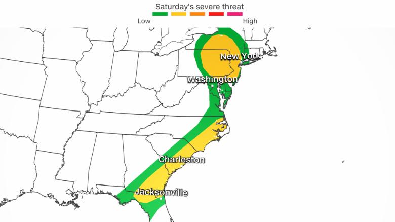
(CNN) – The same damaging storm system that rolled across the Southeast on Friday will continue this weekend, impacting over 50 million people along the East Coast.
“We have potential wind damage and the possibility of very large hail all the way from upstate New York down along the East Coast to northern Florida,” said CNN Meteorologist Chad Myers. “The storms to the north will have more hail and the storms to the south will contain more wind. There is also the possibility that few of the strongest storms could produce a tornado or two.”
Fridays storms brought damage to Kentucky, Alabama, and Florida. National Weather Service crews will be out to survey the damage Saturday to determine if it was indeed caused by tornadoes.
On Saturday, extremely warm temperatures will come into play as well from Charleston, South Carolina, up through Syracuse, New York, where high temperatures will be 10-20 degrees above average.
“A very warm air mass in place for this time of year along the East Coast will feature highs into the 70s and 80s into southern New Jersey,” the Weather Prediction Center said. “This will help fuel the potential for isolated strong to locally severe thunderstorms.”
Myers cautions that while most of the stronger storms will happen in the daylight hours, some may continue after dark.
When tornadoes occur during the day, people are awake, alert, and make a conscious effort to seek out weather alerts. At night, is a different story. This makes it imperative to be sure you have a weather radio, weather app on your phone or any other alerting system to wake you up if you live in an area that is expecting severe storms overnight.
Sunday will provide a brief reprieve from severe storms. By Monday, the next round of severe storms will begin to take shape, a multi-day event that will impact nearly a dozen states.
The risk of severe storms will stem from a low-pressure system working its way through the Western US this weekend.
On Saturday, rain and snow are expected to push in along the coastal regions of Washington, Oregon, and northern California. Rain and snow will shift into the Great Basin/Intermountain West region by the evening, making its way into the Rocky Mountains on Sunday.
Valleys can expect up to one inch of rain, while the higher elevations of the Cascades and Olympic Mountains will see more than a foot of snow this weekend.
By Monday, that system will emerge in the central and southern Plains, areas that will be ripe with the warm and humid conditions necessary to fuel severe storms.
“The severe weather setup is much more pronounced next week with a strong storm system crossing the southern Rockies on Sunday,” Myers said. “The system will create widespread wind, hail and tornadoes Monday through Wednesday across the southern Plains and Deep South.”
The system will gradually make its way from Texas to Florida over a three to four-day stretch, which is not very fast. This also means that flooding could be a concern for some states that receive rain over multiple days.