In Gijon, a small town in northern Spain, a group of architects, artists, programmers and researchers convened around mapping practices as political tools of awareness, advocacy and activism.
Their interest in making maps is rooted in social theories that advocate the dynamism of physical space and its constant reshaping by inhabiting societies and political administration. While many of the projects presented during the meeting are concerned with Spanish geographic sites of contention, other mapping initiatives focus on the Middle East as a site of contemporary conflict where space plays a prominent role.
“It’s not a meeting about the technical features of maps’ making, but about how to use maps as a political weapon,” says Pablo De Soto, the man behind this encounter. Dubbed the golden boy of Gijon, the small town that was hardly hit by globalization, De Soto is one of the few young people remaining in town. Yet, he travels around the world, connects with activist networks and brings them together around common causes.
“Before the Iraq occupation, the neo-conservatives invented a cartography about the Middle East for propaganda and brainwashing purposes to encourage Americans to support the war,” De Soto says, explaining the political function of map making. “The map they made was very simple but effective. It represented the region with all states’ borders, no names on any country and only on the Iraqi border, it was written ‘al-Qaeda’. The map was used by American corporate media to show Iraq as a threat.” With the same token, maps can be used to erase this manipulation, he says. For example, in New York City, individual collectives developed a map showing American companies making benefits out of the occupation of Iraq.
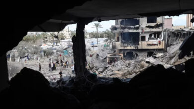
In Lebanon, an ad-hoc collective of activists from different professional backgrounds came together during the Israeli war on Lebanon in 2006, under the umbrella of campaigning against the war. In the process, the collective aspired to produce an alternative narrative of the conflict to the one produced by mainstream media. Maps were one of their tools. “The problem with war images [propagated by the media] worldwide is that you can only see smoke coming out of a building somewhere in the south. This is a problematic image. It became a standard image in portraying war,” says Mansour Aziz, a web-developer and part of the Kharita collective in Lebanon, otherwise known as Solidarity Maps. “The idea is to try to tell stories about what people are doing during the war, to do a dialectical storytelling process.” The product was a process of close documentation of the every-day happenings of the war, with detailed information about the victims, their families and their villages, which could be put to humanitarian and political uses. The resulting data is given to designers who produce maps that can be viewed on two levels. An immediate macro-level that shows the intensification of the bombings throughout the war and a micro-level that shows meticulous details about the nature of the sites bombed. “For an audience that doesn’t know the place, the immediate thing done by the media is to draw a map, where they show the place and say there is some fighting there. The idea was to use the same tool to show how drastic the bombing was.” The Kharita maps were used by several local and international media outlets. For the collective itself, the exercise developed to become an on-going tool of campaigning whenever a conflict takes place. Examples are the maps developed following the conflict in al-Nahr al-Bared Palestinian refugee camp between the Lebanese army and a militia that led to the destruction of the camp in 2007 and the more recent military operation Cast Lead by Israel in Gaza in early 2009.
Another mapping action was born in a workshop in the University of Architecture in Alicante in Spain, in the winter of 2009, just as the Israeli military campaign on Gaza has erupted. Jose Perez de Lama, professor of architecture theory at the university of Seville, who started the workshop alongside De Soto, did not decide to focus on the war on Gaza as an expression of solidarity alone. “We saw what was happening as a laboratory of urbanism that’s been extended to other geographies, yet experienced with different levels,” he says. The workshop participants worked on a critical cartography using map catalogues, computer applications and videos curated together to create a narrative about the war that highlights its spatial dimensions. In a video output, Geographic Information Systems (GIS) and 3D modeling were used to show the geo-political effects of imposing a blockade over the Gaza Strip, hence reversing the traditional functions of an urban space. The video produces a key alternative context to the use of tunnels for the channeling of goods from Egypt to Gaza beneath the official borders between the two spaces as a reaction to the blockade. The workshop also produced a series of maps showing trends of international solidarity during the Gaza war, the refugee dimension of Gaza, which represents significant demographic change throughout time, and other narratives about the Strip that is barely found in international media.
“The idea now is to start giving this work to people in Gaza, to make it as open as possible to the collective intelligence on the ground,” says De Soto who does not see his work as limited to elucidating a group of Spanish students to the realities of the Gaza war and encouraging them to develop a critical narrative through cartographies. De Soto and De Lama perceive a dimension of power in making maps. “A map is about people; people capable of producing maps according to their interests,” says de Lama. Both of them are behind hackitectura.net, a collective which develops research, campaigns and artworks exploring the relationship between architecture, digital space and social networks. Their other main work in the region involves Fadaiat, a tactical cartography of the strait of Gilbraltar mapping geopolitical aspects of border militarization, migration flows and social movements. Working a few years later on Gaza, through the Egyptian bordering town of Rafah, De Soto sees affinities. “I was empowered by my experience in Morocco to explore the broader context of breaching physical borders, breaching the wall in a territory under siege.”