(CNN) – Hidden deep below the ice sheet that covers Antarctica, scientists have discovered a massive amount of water.
The groundwater system, found in deep sediments in West Antarctica likely to be the consistency of a wet sponge, reveals an unexplored part of the region and may have implications for how the frozen continent reacts to the climate crisis, according to new research.
“People have hypothesized that there could be deep groundwater in these sediments, but up to now, no one has done any detailed imaging,” said the study’s lead author, Chloe Gustafson, a postdoctoral researcher at the University of California San Diego’s Scripps Institution of Oceanography, in a news statement.
“Antarctica contains 57 meters (187 feet) of sea level rise potential, so we want to make sure we are incorporating all of the processes that control how ice flows off of the continent and into the oceans. Groundwater is currently a missing process in our models of ice flow,” she added via email.
The ice cap that covers Antarctica isn’t a rigid whole. Researchers in Antarctica have discovered in recent years hundreds of interconnected liquid lakes and rivers cradled within the ice itself. But this is the first time the presence of large amounts of liquid water in below-ice sediments has been found.
The authors of this study, which published in the journal Science on Thursday, concentrated on the 60-mile-wide (96.6-kilometer-wide) Whillans Ice Stream, one of a half-dozen streams feeding the Ross Ice Shelf, the world’s largest, at about the size of Canada’s Yukon Territory.
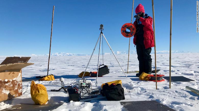
Gustafson and her colleagues spent six weeks in 2018 mapping the sediments beneath the ice. The research team used geophysical instruments placed directly on the surface to execute a technique called magnetotelluric imaging.
The technique can detect the differing degrees of electromagnetic energy conducted by ice, sediment, bedrock fresh water and salt water and create a map from these different sources of information.
“We imaged from the ice bed to about five kilometers (3.1 miles) and even deeper,” said coauthor Kerry Key, an associate professor of earth and environmental sciences at Columbia University, in a separate statement.
The researchers calculated that if they could squeeze the groundwater from the sediments in the 100 square kilometers (38.6 square miles) they mapped onto the surface, it would form a lake that ranged from 220 to 820 meters (722 to 2,690 feet) deep.
“The Empire State Building up to the antenna is about 420 meters (1,378 feet) tall,” Gustafson, who did the research as a graduate student at Columbia University’s Lamont-Doherty Earth Observatory, said in the statement.
“At the shallow end, our water would go up the Empire State Building about halfway. At the deepest end, it’s almost two Empire State Buildings stacked on top of each other. This is significant because subglacial lakes in this area are two to 15 meters (6.6 to 49 feet) deep. That’s like one to four stories of the Empire State Building.”
How did it get there?
The mapping revealed that the water got saltier with depth, which was a result of how the groundwater system formed.
Ocean water likely reached the area during a warm period 5,000 to 7,000 years ago, saturating the sediment with salty seawater. When the ice advanced, fresh meltwater produced by pressure from above and friction at the ice base was forced into the upper sediments. It probably continues to filter down and mix into the groundwater today, Key said.
The researchers said more work needed to be done understand the implications of the groundwater discovery, particularly in relation to climate crisis and rising sea levels.
It was possible that the slow draining of water from the ice into the sediment could prevent water from building up at the base of the ice — acting as a brake for the ice’s forward motion toward the sea.
However, if the surface ice cap were to thin, the reduction in pressure could allow this deep water to well up. This upward movement would lubricate the base of the ice and accelerate its flow.
“This finding highlights groundwater hydrology as a potentially critical piece in understanding the effect of water flow on Antarctic ice sheet dynamics,” Winnie Chu, an assistant professor at the Georgia Institute of Technology, wrote in a commentary on the research that was published in Science. She was not involved in the study.