The Egyptian Meteorological Authority (EMA) announced that Thursday will see the peak of rising temperatures across the country, with hot weather prevailing during the daytime, becoming milder at night and in the early morning.
Some areas will see very hot conditions in some areas, particularly south of the country.
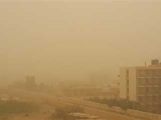
This will coincide with active winds stirring up sand and dust in different areas, particularly the western coasts, Greater Cairo, and northern Upper Egypt, which impact horizontal visibility.
The weather forecast also indicated a chance of light to moderate rainfall, accompanied by occasional thunderstorms, in parts of Sinai and the Red Sea mountain range.
Temperatures to gradually decrease
Weather maps predict that starting Friday, April 17, temperatures will begin to decrease gradually by two to five degrees Celsius across northern Egypt, extending to Greater Cairo and northern Upper Egypt.
Dust-laden winds will potentially impact visibility in some areas.
This unstable weather pattern is expected to persist until Monday, April 20, with intermittent active winds carrying sand and dust, particularly in open areas.
Greater Cairo and the Nile Delta are expected to reach highs of around 35C on Thursday, and 38C in Upper Egypt. Temperatures are then expected to gradually decrease over the following days, reaching 27C in both Cairo and Upper Egypt by the end of the period.
The EMA confirmed that spring typically sees rapid changes in weather conditions and the activity of dust storms known as Khamsin winds. It urged citizens to stay updated and take necessary precautions, especially those with allergies and respiratory conditions.
Edited translation from Al-Masry Al-Youm